
FloodMapp – Real Time Emergency Flood Data

“A friend lost everything when floodwaters reached the peak of her roof. As a water resources engineer, I thought we could do better.” – Juliette Murphy, Co-Founder
The Company
FloodMapp is a Brisbane, AU based startup, using AI-powered models to equip government agencies, utilities, logistics companies and insurers in Australia and the United States with real-time flood inundation modelling that can achieve large scale, rapid modelling, as well as forecast inundation depth down to an individual street address. The company seeks to replace traditional approaches to hydrology and predictive analytics to help emergency managers and citizens know when and how floods are coming.
The Issue
Flood cause widespread damage to neighborhoods, infrastructure, communities, and, of course, people. Flooding is predicted to displace 50 million people by 2100. The U.S. government estimates that floods in recent decades (exclusive of hurricanes and tropical storms) have caused an estimated $160 USD billion in damage and killed hundreds of people. A Deloitte study from 2017 showed natural disasters cost Australia $13.2 AUD billion a year in economic damages. This is predicted to triple to $39.3 AUD billion by 2050, even without considering climate change. Of this, flooding costs the economy $8.8 AUD billion a year.
The Solution and Value Creation

Existing solutions rely on our understanding of physics and hydrology. Given the topology of a location, one can predict water flow. However, the computational costs associated with doing so are incredibly high. FloodMapp uses a completely data-based approach that takes advantage of widely available techniques in machine learning to make those calculations much more palatable, a new top down approach versus the traditional bottoms up methodology.
This approach led to the creation of DASH (Dynamic Automated Scalable Hydroinformatic), the startup’s real-time flood model. DASH creates reports on current, future, and past flood conditions within an area, called ‘NowCasts’, ‘ForeCasts’ and ‘PostCasts’. FloodMapp achieves this by first collecting valuable data, by being to every river and rain gauge and digital elevation model across Australia. This includes collecting forecast and observed rainfall, river height at the target gauge and its upstream network, as well as past flood data. All of these data points are fed into their machine learning model.
NowCast
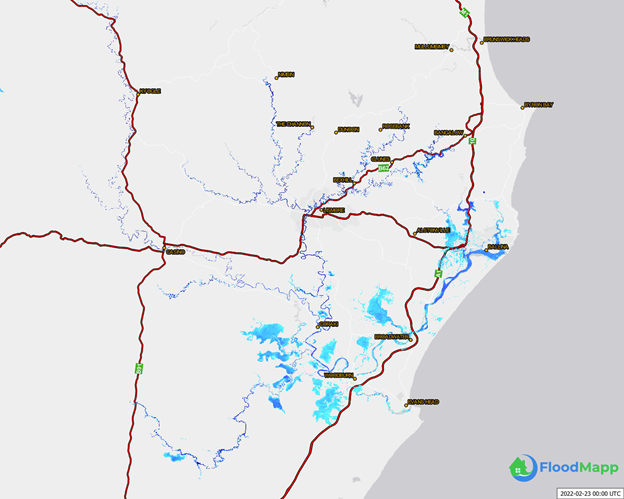
FloodMapp’s modeling of real time flooding (NowCast) near Brisbane, AU. Image Credits: FloodMapp
ForeCast
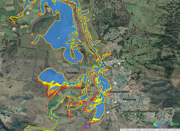
FloodMapp’s modeling of forecasted flooding, with colors showing severity by flood level (ForeCast) near Brisbane, AU. Image Credits: FloodMapp
PostCast
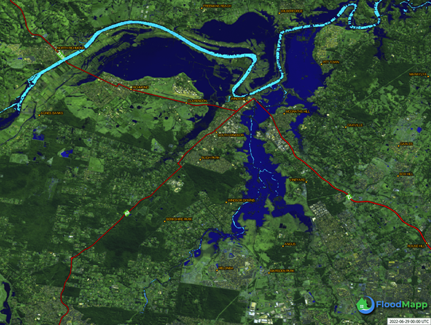
FloodMapp’s modeling of post flood damage (PostCast) near Sydney, AU. Image Credits: FloodMapp
Customers
While FloodMapp plans on servicing a variety of industries as a data provider, it currently focuses on providing emergency service providers, like the Queensland Fire and Emergency Services and as the cities of Norfolk and Virginia Beach in Virginia, to generate extra lead time and post flood damage reporting to interested parties (regulators, management, etc).
Floodmap provides customers a data layer, which customers pay a subscription fee for access to. This data layer typically folds into or compliments FloodMapp’s customers existing systems, such as providing warnings or road closures which a fire department may forward onto citizens. This is usually done through geographic information systems (GIS) that can be combined with other data streams to provide situational awareness to emergency response and recovery personnel.
FloodMapp hopes to expand to other industries, such as players with large investments in physical assets: including retail banks and clothiers, telecom and power companies, or infrastructure or mining companies. Australia’s large mining industry can benefit by getting a picture of potential impact to their site before a flood happens, preventing damage to equipment, minimize lost production, and mitigate business interruption. That could include relocating machinery and equipment to higher ground, bringing in more pumping infrastructure, or shipping more product before critical rail infrastructure is closed. There is also hope that the SEC will mandate further climate change financial disclosures, pushing companies to improve their risk profile to climate and flooding disasters.
FloodMapp has also been looking to expand through partnerships, notably through integration with Waze by rerouting drivers away from flooded areas. The real time information generated by DASH (fed by rainfall, tidal, and riverine data) is layered with Norfolk’s citywide road network and sent to Waze. Drivers who then use Waze receive pop-up icons and audio alerts to warn them about flooded streets along their route and help them avoid property and life-threatening hazards. Drivers can confirm flooding in the app, which helps validate FloodMapp’s technology and makes future Waze alerts more accurate.
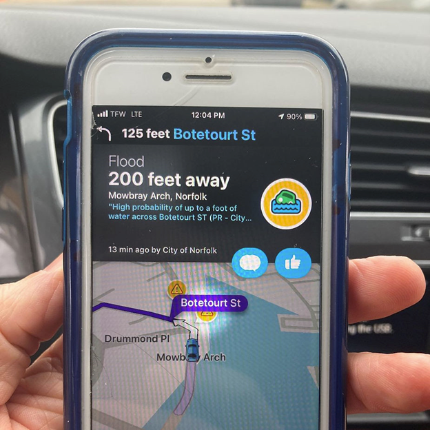
FloodMapp Waze integration example in Virginia, USA. Image Credits: FloodMapp
Challenges and Recommendations
As FloodMapp continues to expand and improve its products and services, they will likely have a few challenges to surmount or mitigate:
- Data Quality –
- FloodMapp faces significant data quality issues. Because DASH relies on information generated through local infrastructure, stream gages can go offline due to regular maintenance, noncompliance, lack of calibration, changes in protocol, or damage in a flood event.
- Luckily, FloodMapp can supplement its data as well as fix some of these issues through satellite imagery and, surprisingly, more machine learning. Satellite imagery can be used to both verify real time data, when available, and create and validate machine learning models. Gauge data issues can be mitigated by creating classification machine learning algorithms around identifying cause of failure (and therefore how to categorize the missing data) and searching for outliers as far as reliability.
- Expansion Resistance
- One of FloodMapp’s chief problems will not be technical, but human. Any company that sells to government clients must deal with long term sales processes and typically very demanding requirements to provide robust services, especially when lives are at stake. FloodMapp will have to learn how to partner, and sell, to increasingly larger government and private clients which will require an increasingly large demand on their resources, especially given that the company is approximately 25 people in size currently.
- Organizationally, FloodMapp will have to curate skills (sales, service, technical) to scale. To alleviate this issue, FloodMapp will either have to get a very good sales team, a very good customer service team, or work with partnerships that would allow them access to a large number of entities at once, such as a national fire department or weather alert institute.
Sources:
https://www.floodmapp.com/post/innovation-for-emergency-managers
https://www.floodmapp.com/post/machine-learning-for-data-quality-problems
https://www.floodmapp.com/post/machine-learning-for-data-quality-problems
https://www.floodmapp.com/post/accurately-assess-damage-after-flooding-with-floodmapp-postcast
https://www.floodmapp.com/post/satellite-imagery-vs-real-time-intelligence
https://techcrunch.com/2021/08/18/floodmapp-climate-change-flooding/
https://createdigital.org.au/using-ai-to-save-lives-and-property-from-floods/
Fascinating post! It was really interesting to see how the value of machine learning in this application was not only about the amplification of computing power, but changing the methodology of flood prediction itself–from bottom-up to top-down. I agree that one of the main challenges will be managing the sales process. It definitely seems like there would be a huge market for this product across the public and private sectors, but both governments and the large private sector organizations that are likely to be interested will have relatively long sale cycles.
Super interesting post, I think they have tapped into what will become an increasingly larger and more relevant market as cities start to think how to adapt to climate change. It’ll be interesting to see whether they can scale and expand to more geographies and to potentially extend their model to other kinds of natural disasters and offer a full suite for emergency services management to governments. I think their integration with Waze is particularly smart as you mention the real time validation of the model outputs.
Super interesting! I think the B2B approach makes so much sense here vs. trying to use it to better inform individuals and households. Too often the injuries, deaths, and other serious damages caused by floods and other disasters are because people have ignored the warnings given by local officials and refused to evacuate or take appropriate precautions. I suspect that business have a lower risk tolerance regarding these sorts of issues given that it can seriously impact profits, their workforces, and their customer base and therefore revenues.
At the same time, part of the challenge will be training companies how to actually use the data correctly, and how to ensure that their front-line workers (e.g., the ride-share driver) following the AI’s recommendations too. It’s the same problem as going B2C except this time you have the client company as a middle man and invested change agent. I’ll be curious to see if/how this gets rolled out and becomes more prevalent!
My partners mom lives on an island off the coast of Brisbane AU and she is flooded out every year. I’m going to share this company with her! I found how they are partnering with Waze and Public Service Agencies as a means of monetizaiton an interesting an important step to create value across end users. I’m also interested in how asset managers could use this for their climate risk planning as you alluded to.