Planet Labs: A Satellite Startup Takes a Flight to Feed the World

As global food production struggles to meet rapidly growing demand, a nanosatellite startup dares to photograph the entire planet every day, providing unprecedented visibility and business tools to feed the world.
Let Them Eat… What?
According to the UN Food and Agriculture Organization, the world’s farmers will need to produce 70% more food (relative to 2006 levels) to meet the demand of 9.2 billion people projected to inhabit the planet by 2050.[1] Further intensifying this pressure is global climate change. Extreme weather events like droughts and flooding, and long-term changes such as rising sea levels are damaging crop yields and shortening growing cycles. Production levels are already flattening, with yield plateaus, or even abrupt drops in yield gain, among 31% of total global rice, wheat and maize production.[2] As most of the land suitable for farming is already farmed, incremental food production globally must come from higher yields.[1]
Getting “Smarter”
But fear not, the “it” technology of the day, namely Internet of Things, has come to the industry’s aid. Smart farming aims to make existing arable land more “intelligent” through an amalgamation of connected technologies, such as[3]:
- Sensors to collect information on productivity factors, including temperature, humidity, soil moisture and nutrient content, threat from weeds, pests and diseases
- Software to monitor input and remotely control connected harvesters and irrigation equipment;
- Unmanned aerial vehicles to control crop picking; and
- Geospatial technologies to monitor and optimize crop health and production and farm operations.
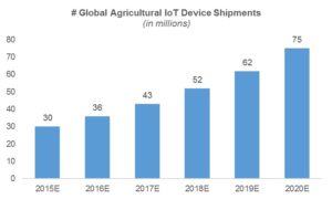
The U.S. is leading the way in industry sensor deployment, with a 33% year-over-year increase in smart agriculture network connections in 2015, trailing energy (58%) and transportation (49%), but outpacing healthcare and pharmaceuticals (26%).[4] Analysts estimate global agricultural IoT device shipments will continue growing at a healthy 20% CAGR to 75 million units by 2020.[5]
Exhibit 1: Global Agricultural IoT Device Shipment Forecast[5]
Planet Labs: Picturing the Earth Every Day
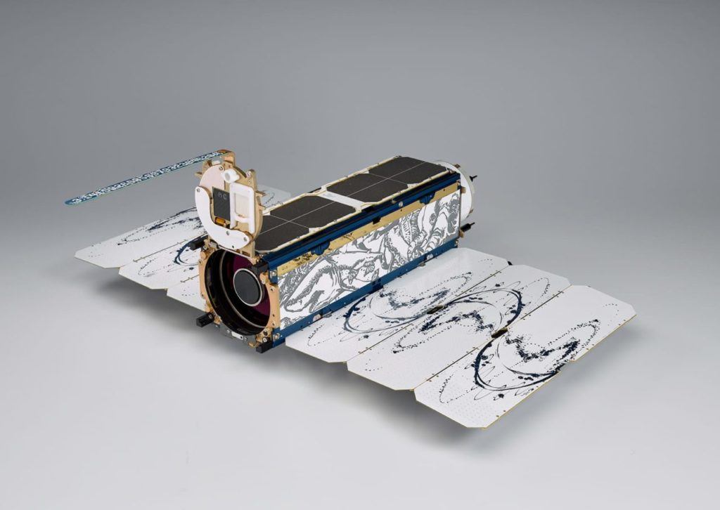
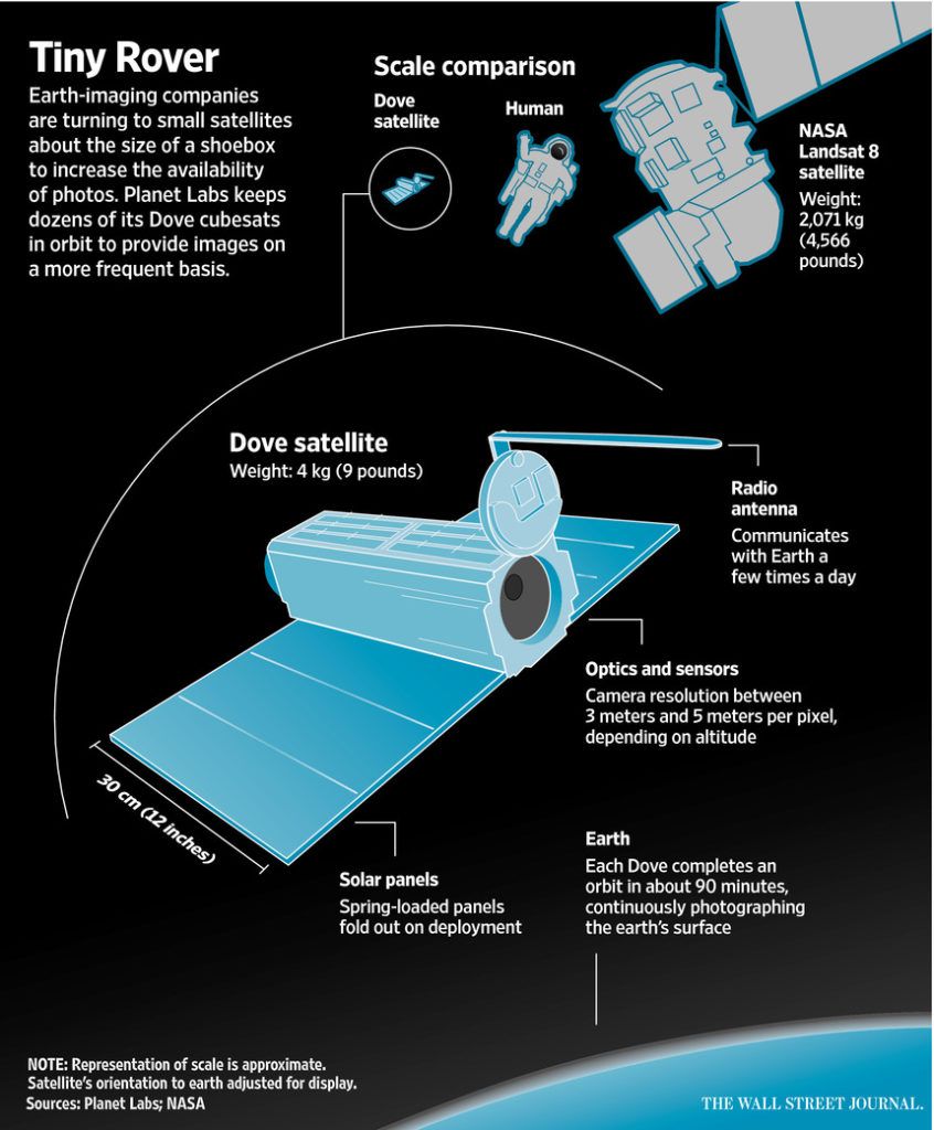
For many technology and food providers, climate change triggers noteworthy changes in business strategies and operations. In the case of Planet Labs (also known as Planet), it gives the six-year-old startup its entire raison d’être. The company (which has raised $183 million, most recently at $1.1 billion valuation) founded by ex-NASA scientists is working to make the Earth’s changes more visible and actionable for farmers.[6][7] It deploys small (measuring 12 inches and weighing 4-5 kg), low-cost, high-frequency imaging satellites to photograph remote parts of the world for agriculture, disaster response and urban planning applications.[8][9]
Exhibit 2: Dove Satellite[8][9]
Exhibit 3: Dove Satellite at a Glance[10]
Its fleet of nano, low-orbiting satellites called Doves typically hitch a ride on rocket launches to the International Space Station and similar projects, including shipment ferries by Elon Musk’s SpaceX. Today, the company has 62 satellites in orbit and aims to have 100 by end of the year – enough to get a photo of the Earth’s entire land mass every day at 3-5 meter per pixel camera resolution.[10][11]
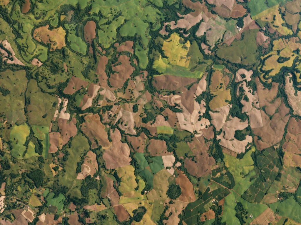
Doves are specifically suited for land use observation, via health and types of agricultural crops, extent of logging and deforestation and availability of water.[11] They do so faster and less expensively than traditional satellites, whose pixel-rich images and large-scale deployments are often cost-prohibitive.[12] Planet’s value proposition is quantity, not quality. Based on the breath of landmass images, it delivers a constant stream of up-to-date information to farmers, corporations and governments to identify changes in crops, soil and water availability, thereby informing strategic decisions around monitoring yield, tracking farm operations and scouting crops.
Exhibit 4: Dove satellite image of sugar cane fields in Rio Grande do Sul, Brazil (March 2016)[13]
Flying Forward
In order to achieve target refresh rate of the full Earth every day, Planet must dedicate significant additional resources to accelerate production, which is still done at its SF headquarters. It announced this March that it would begin manufacturing 120 units in a six-week span, the fastest manufacture of satellites to date.[11]
More critically, Planet must continue to advance its data analytics capabilities that translate images into tangible action plans. Today, it works with third-party firms such as Descartes Labs, FarmLogs and FarmersEdge.[11] The next step in its evolution is a simple, fast decision tool for individual growers. Planet is currently developing a software platform for “one-click change analysis across different imagery, seeing roads, towns, and other major features there weren’t there a week, month or year before. For what required hours of expert analysis, now it’s a toggle switch.”[11][12] Furthermore, by connecting the image database with field equipment and back-end IT infrastructure, it can automate and improve production. One use case is a farmer running images of his land through an algorithm and determining the soil makeup of each part of the field. He then remotely directs tractors to automatically apply the right type of fertilizer in each area. This not only saves him time, but also reduces his fertilizer usage, which in returns curbs runoff of nitrate into nearby water sources.
As the saying goes, a picture is worth a thousand words. Planet Labs’s 50-trillion-pixel daily photo of every spot on our rapidly evolving planet, has the potential to be worth a whole lot more – by empowering the world’s food growers to optimize production, maximize crop yields and feed the world.
[Word Count: 800]
[1] “Technology Quarterly: The Future of Agriculture,” The Economist, June 9, 2016, http://www.economist.com/technology-quarterly/2016-06-09/factory-fresh, accessed November 2016.
[2] Nafeez Ahmed, “Dramatic Decline in Industrial Agriculture Could Herald ‘Peak Food’”, The Guardian, December 19, 2013, https://www.theguardian.com/environment/earth-insight/2013/dec/19/industrial-agriculture-limits-peak-food, accessed November 2016.
[3] “Smart Farming: Agriculture for the future”, AgriTech, July 9, 2015, https://agritech.blog.gov.uk/2015/07/09/smart-farming-agriculture-for-the-future/, accessed November 2016.
[4] “State of the Market: Internet of Things 2016,” Verizon, https://www.verizon.com/about/sites/default/files/state-of-the-internet-of-things-market-report-2016.pdf, accessed November 2016.
[5] Andrew Meola, “Why IoT, Big Data & Smart Farming is the Future Agriculture,” Business Insider, October 7, 2016, http://www.businessinsider.com/internet-of-things-smart-agriculture-2016-10, accessed November 2016.
[6] Ryan Lawler, “Planet Labs Nabs $95 Million and a New COO to Cover the Earth with Flocks of Tiny Satellites,” TechCrunch, January 20, 2015, https://techcrunch.com/2015/01/20/planet-labs-95m/, accessed November 2016.
[7] “IFC Invests in Planet Labs to Improve Access to Emerging Market Satellite Imagery,” International Finance Corporation – World Bank Group, April 13, 2015, http://ifcextapps.ifc.org/ifcext%5Cpressroom%5Cifcpressroom.nsf%5C0%5C74AF6601CDB3D8B485257E260063B42D, accessed November 2016.
[8] Planet Labs, https://www.planet.com/markets/monitoring-for-precision-agriculture/, accessed November 2016.
[9] “Planet Labs at a Glance,” Planet Labs, November 2015, http://lps16.esa.int/posterfiles/paper1053/1512.14%20One%20Sheet%20v4.pdf, accessed November 2016.
[10] Bradley Hope, “Tiny Satellites: The Latest Innovation Hedge Funds Are Using to Get a Leg Up,” Wall Street Journal, August 14, 2016, http://www.wsj.com/articles/satellites-hedge-funds-eye-in-the-sky-1471207062, accessed November 2016.
[11] Robinson Meyer, “A New 50-Trillion-Pixel Image of Earth, Every Day,” The Atlantic, March 9, 2016, http://www.theatlantic.com/technology/archive/2016/03/terra-bella-planet-labs/472734/, accessed November 2016.
[12] G. Burningham, “How Satellite Imaging Will Revolutionize Everything from Stock Picking to Farming, Newsweek, September 8, 2016, http://www.newsweek.com/2016/09/16/why-satellite-imaging-next-big-thing-496443.html, accessed November 2016.
[13] Matteo Luccio, “Planet Labs,” Apogeo Spatial, May 13, 2016, http://apogeospatial.com/planet-lab/, accessed November 2016.


It will be very interesting to see Planet Labs’ progress over the next few years. They seem to have successfully established themselves in generating high-frequency, high-quality satellite images and making that content accessible. However, the true value of this innovation will be the ability to extrapolate agronomic decisions from these images, and emerging agricultural startups are starting to focus on this function as satellite images are becoming more accessible. For example, Descartes Labs aggregates imagery from companies like Landsat, Planet Labs, and the European Space Agency and then uses machine learning techniques to provide data-driven insights and analyses on farming and land use. Perhaps Planet Labs should seriously consider acquiring a target in this space to further bolster their product offering.
I appreciate how you show a really great example of a company that sees climate change as a business opportunity! There is no doubt that farmers are in need of technology to help them monitor farming conditions to ensure more stable yields despite more drastic changes in weather patterns. However, the big question in my mind with regards to Planet Labs is whether farmers in developing nations will have the resources and infrastructure to utilize the data and insights generated by Planet Labs. Specifically, does a farmer in rural Northern Africa or South America have access to sufficient internet bandwidth and the right devices to download the data from Planet Labs and to determine what actions to take in response? Does Planet Lab provide any data insight generators or actionable suggestions to the farmers?
This article provides a new perspective on how Internet of Things technologies can have wide reaching implications beyond asset surveillance, with some particularly interesting use cases in the field of agriculture. I wonder how technology companies tackle the cultural gap that exists between Silicon Valley and farming communities, a gap that it is even wider in developing countries. As a previous comment pointed out, there are infrastructure problems that will need to be solved to harness the technology’s potential, but the greater challenge seems to be finding ways to change behavior and attitudes and address knowledge gaps. This question is not new, but finding an answer is becoming increasingly more urgent. For an example, see this debate on the topic: http://www.scidev.net/global/agriculture/multimedia/debate-farmers-tech-innovation.html.
This is fascinating and, through the ‘lens’ of my military experience, presents some really interesting security concerns and opportunities. I’m curious if at some point Planet will be directed by governments to limit the availability of data so that only specific landowners or government agencies can access it. The risk of equipping anti-government groups with this kind of near-real-time field positioning information is that it could enable much more effective guerrilla warfare operations – particularly where government forces are spread thin. On the other hand, under-resourced national security organizations could use this data to defend against such activities. I suspect this will become an even more complex ‘conversation’ as the technology is deployed further.
Fascinating read, Eunji! There’s a huge opportunity here to integrate technology with precision farming to continuously monitor and improve crop yield, and as you point out, to turn the mass of surveillance images into decision tools as well as an input into automated production. But there do remain a few open questions, most of which others have alluded to. One, there’s a very real risk of inequity of accessibility. Farmers who have inferior financial wherewithal or technological savviness, for example, may not reap the rewards of this technology, potentially widening the gap in farmer productivity, and burdening government entities to more heavily subsidize the laggards. And to build on Luke’s concern around security, I definitely worry about the susceptibility to data theft and cyber exploitation. Data integrity, and engagement of farmers in data management will have to be something that Planet addresses going forward.
If interested, take a look at a note FBI issued earlier this year to call out the cyber risks of precision farming: https://info.publicintelligence.net/FBI-SmartFarmHacking.pdf
Eunji – Very interesting article on how low-cost, high-frequency satellite imaging will provide useful data to help farmers adapt to the changing environment. But what is the environmental impact of placing these satellites into orbit? Planet Labs has lost dozens of satellites in recent launch explosions such as the Orbital Sciences Corporation Antares rocket explosion in Virginia and a SpaceX Falcon 9 launch failure. Even when the launch is successful these rockets use fuels such as kerosene that produce greenhouse gases that deplete the ozone layer. While rocket launches currently account for a small percentage of human emitted greenhouse gases released into the atmosphere, an increase in launches combined with the phase-out of CFCs and HFCs may result in a higher relative proportion of atmosphere damaging pollution in the future. For example, Planet Labs has announced that it will be using Rocket Lab’s Electron rocket for upcoming launches and Rocket Labs intends to provide hundreds of launches per year for its customers using its kerosene-fueled Electron rocket. From a climate change perspective one hopes the environmental benefit of these satellites will offset the environmental impact of launching a satellite into space.
http://spaceflightnow.com/2015/09/20/planet-labs-takes-rash-of-launch-failures-in-stride/
https://www.sciencedaily.com/releases/2009/03/090331153014.htm
Great article Eunji! Very interesting to see the boundaries being pushed on how the agriculture industry can deploy technology to improve yields. Would also love to see how this can be used to help rural farmers in undeveloped areas. These places often have no network connections yet are vital in terms of the global agriculture industry.
Eunji – this is a AWESOME post. Sounds like a VERY cool company. I was blown away by some of the facts – satellites the size of a shoe box circulating the globe every 90 minutes – holy cow!! I think that data analytics will play a massive role in the future of this company. I think it is an incredible effort and am impressed by how they photograph the earth on a daily basis. I think the key for this business is how do they maximize the potential of the photos they are taking. I agree that data analytics can help unlock this value. I also had one quick question regarding the number of “shoe box” satellites the company is launching into orbit. You mention the company plants to have 100 in orbit by the end of the year. At what point does the company start worrying about satellite pollution – i.e. too many satellites orbiting the plant / crashing into each other? Is that even a reasonable concern at this stage? Something worth considering going forward? Great work!
Eunji, this is a fascinating, well-written post that has generated some great discussion. Questions that Hannah and Sam raise below around whether farmers in developing nations will be able to access and act upon data provided by Planet are important, especially given that the majority of the world’s food supply is produced by smallholder farmers. I’m curious to understand how Planet intends to market and sell its product, especially to farmers in low- and middle-income countries, and to know what you would recommend as an optimal approach? Pricing and revenue recognition models that we have discussed in FRC (subscription!) come to mind.
One related question I had – and one that links to Luke’s concerns about security – is whether Planet has negotiated or intends to negotiate specifically with governments in developing countries to disseminate the data it collects about agriculture? In the global health space, sensitivity of data is a constant concern; governments rarely want to share specific information about programs with external parties, as data – even in the aggregate, not at the patient-level – may show that programs are not performing as well as one expects. Do you think Planet will run into any data sensitivity challenges as it expands its reach?
This is huge! A very interesting argument for the supply-side. Another interesting approach in the “future of food” arena is that taken by Soylent, providing full nutrition strictly derived from chemicals. There’s definitely data missing to prove their approach is healthy to the human body in the long-term but if it is, then food production as know it could radically change. Another issue I think a lot about is distribution of food. Many countries, like Argentina, produce much more than they need to consume and yet they still have people dying from hunger. Sometimes I wonder whether the largest impact lies in driving production efficiency or distribution efficiency…