AgEagle Takes Flight: A New Way of Helping Farmers Scope out the Field

AgEagle is one of the pioneers in the field of Precision Agriculture, where data is being used to improve agricultural output. Take a bird's eye of view of this exciting industry that is poised to improve the way the world produces food.
A drone, more formally known as Unmanned Aerial Vehicles (UAVs), are essentially flying robots. These machines can either be flown remotely or fly autonomously using software on the ground. Drones are usually equipped cameras, sensors, GPS or even weaponry to allow it to perform a host of tasks.[1]
Not too long ago, drones were often associated and used in the military. In recent years, however, use of drones have expanded to a wide range of civilian activities including search and rescue operations, traffic analysis and monitoring, surveillance applications, weather charting and forecasting, photography, and delivery services. [2]
One of the more interesting applications of drones, however, is in agriculture. This application is central to a growing industry called Precision Agriculture and one of the major players is Kansas-based AgEagle Aerial Systems. [3]
Enter AgEagle
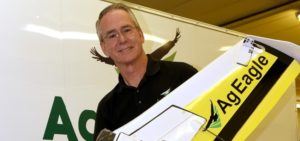
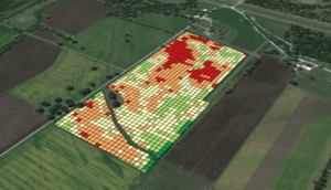
AgEagle is a leading provider of state-of-the-art UAVs used for data acquisition for agriculture. AgEagle’s drones can launch and land on its own needing only a flight path. These drones can quickly capture aerial images and stitch them all together. The resulting image, called the prescription map, can identify areas of stress that the farmer can then use to respond quickly – potentially avoiding pest infestations, unwanted soil variations and problems on irrigation.[4]
AgEagle was born from a collaboration between founder Brett Chilcott and the Kansas State University. Throughout 2011, Kansas state had been working on merging small radio controlled airplanes and infrared photo image technology to assess land and crop quality. Seeing this, Brett and professors in Kansas state saw the immense potential for applications in agriculture.

By 2012, AgEagle’s first drone prototype was completed and was tested alongside farmers and agronomists. Feedback was positive and by the fall of 2013, the first AgEagle drone was sold. Since then, AgEagle has continued to expand its business and has now sold drones across the United States, Canada, Australia and Brazil.
Benefits of Precision Agriculture
The recent improvements in drone technology is helping farmers across the globe in capturing three types of views: aerial patterns, multispectral images and time-lapse data. Aerial pattern images quickly reveal to farmers any possible problems brought about by improper irrigation along with differences in crop health brought about by pests and soil variation. Multispectral images deploy technologies such as IR mapping that shows differences between healthy and stressed plants that cannot be seen by the naked eye. Time-lapse data shows the progression of crop quality throughout days, months and weeks. This information allows farmers to anticipate trouble spots across the field and find solutions for better crop management.

All this information can be used alongside other technologies such as autonomous tractors, GPS guided harvesters, and automated irrigation and pesticide systems. The data can also be sent to wireless servers that make use of sophisticated software to analyze agricultural patterns deeper – providing better insights for the farmers.[5]
AgEagle’s core technological advantages include a tough carbon fiber frame making the drone resilient to challenging wind conditions, a proprietary filter for its camera and the capability to upload stitched images even while the drone is still in-flight – providing real-time visibility of the field.[6]
The Future Flight Path for AgEagle
The technology and related costs behind AgEagle’s drones have changed significantly since its inception. According to AgEagle’s Business Development Manager Tom Nichol:
“when AgEagle started, the most popular sensor was a modified Canon S100 because NIR (Near Infra Red) sensors cost over $12,000! The Canon cost only $800 or so. Now, multispectral sensors can be purchased for around $3,200 whereas three years ago; those cost $20,000! Sensor prices are coming down. Aircraft autopilots are more dependable and accurate. Air frames have advanced from flimsy foam bodies to incredibly strong carbon fiber encased fuselages. Flight times have increased. Mission planners are much more complex and capable.”[7]
But while the technology and costs are significantly declining, he suggests that the bigger opportunity is still how the data is used.
There are many ways that the data can be used further – from monitoring livestock to anticipating crop behavior in relation to weather. In addition, there are opportunities for these drones to interact with other parts of the agricultural technology infrastructure to make adjustments automatic and seamless. For example, software can be developed so that drones, upon gathering data, can tell irrigation systems to adjust water output without needing any input from the farmer.
Clearly the potential for precision agriculture is vast and we are barely scratching the surface of this technology. Positive impacts can range from minimizing water input and pesticide use to maximizing yield and crop output. These are the things that AgEagle needs to look out for as adoption of Internet of Things improve over the next few years. Clearly AgEagle is well-positioned to take advantage of this rapidly growing field.
Word Count: 793 words
[1] IoT Agenda. 2016. What is drone (unmanned aerial vehicle, UAV)? – Definition from WhatIs.com. [ONLINE] Available at: http://internetofthingsagenda.techtarget.com/definition/drone. [Accessed 14 November 2016].
[2] Ibid.
[3] Ibid.
[4] AgEagle | About. 2016. AgEagle | About. [ONLINE] Available at: http://ageagle.com/about/. [Accessed 14 November 2016].
[5] Chris anderson. 2016. MIT Technology Review. [Online]. [14 November 2016]. Available from: https://www.technologyreview.com/s/526491/agricultural-drones/
[6] Ageaglecom. 2016. Ageaglecom. [Online]. [14 November 2016]. Available from: http://ageagle.com/why-ageagle/
[7] Agfundernewscom. 2016. AgFunderNews. [Online]. [14 November 2016]. Available from: https://agfundernews.com/ageagles-tom-nichol-discusses-development-of-drones-for-ag5665.html


Great post. The ability for farmers to efficiently and effectively evaluate their crops in a manner that is more economical than the alternative (no need to pay for someone to fly above your crop) will certainly play a role in helping farmers increase their yields to help meet the upcoming challenge of feeding an ever growing global population. It will be interesting, however, to see which farmers are able make the necessary investments in a drone like AgEagle’s and other new age equipment. Prices for these technologies are coming down, but many farmers who are continually being squeezed may not have the financial resources to make these investments that allow them to work smarter and more effectively. Will these new investment requirements to remain competitive create a movement of consolidation among the farming industry?
I am a huge fan of seeing innovators like Brett use technology to improve real life products that can directly help the end consumer. Being an advocate of products such as UAVs in agribusiness, my mind jumped to the cost benefit analysis. What are the tangible before and after results a farmer can achieve because of this technology? In order for this system to be marketable we have to be able to prove beyond doubt that this is worth both the farmers money and time to understand and use the UAV. Given the costs will only continue to decline, if we can prove the incremental benefits of these UAVs, I am bullish on this type of company going forward.