Mapillary: mapping the world with crowd sourced photographs

Mapillary is leveraging crowds to collect street level images and stitching them together into an enormous 3-D map to help make the world more accessible to everyone.
Mapillary is using crowd sourcing to map the world with photographs, making the entire world accessible to everyone. To start, Mapillary is creating an open and “intelligent” version of Google’s street view, but they are also taking on much more.
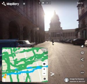
In 2014 Mapillary started with a free smartphone app that allowed users to upload photos taken with their smartphones. Photos were overlaid onto opensource mapping platforms MapBox and OpenStreetMap to build its database of image. Mapillary also stitches the photos together using proprietary computer vision software to create an ever-evolving 3-D vision of the world. Users are able explore images in the georeferenced photo library to get a first-person vision of a location. Google earth street view uses photos taken by cars, limiting the scope to roads. Because Mapillary’s crowd sources mobile uploads, they have the potential to create a visual index of the furthest corners of the earth. The company currently hosts over 250 million photos across seven continents. Mapillary mapped the streets of Havana before there were opportunities to see them for oneself
The CEO purports that people are self-motivated to upload photos because it helps them solve problems. There is a heartfelt manifest and call-to-action on the website encouraging users to upload photos. In general, the people who use the platform also contribute to it, so there are more robust datasets in the locations where there is higher demand for the product. Therefore, through forces of demand and supply, the platform has the potential to grow organically. However, it it is difficult to understand the degree of this alleged intrinsic motivation to upload photos. It might be necessary to implement measures to drive increased upload volumes in the future to provide an up-to-date, comprehensive photoset. Mapillary could consider rewarding users for uploading more photos, or for gamifying the system.
There are no advertisements or other means to monetize the consumer facing portion of the service. All value capture is through the B2B portion of the service, which has a tiered pricing plan based on the number of photos and data viewed ($250/month to view 500,000 photos and negotiated contracts for larger customers). Mapillary provides their B2B clients with the images, data extracted from the images, and other image processing services. They also provide private photo repositories where only authorized users can access the imagery data and services. Early customers included city governments and agencies responsible for infrastructure project maintenance, for example.
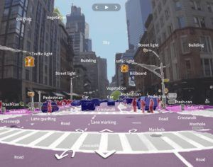
Mapillary’s vision doesn’t stop here. In 2015, Mapillary started partnering with Esri’s GIS, which allows Mapillary’s imagery to be combined with powerful geospatial data. Thanks to the partnership, it is now possible for GIS technology to create, update, and delete features in street level imagery, increasing the value to its B2B customers who use the powerful geospatial technology. More recently, Mapillary has opened a curated portion of its dataset to help train machine learning for autonomous vehicles. Mapillary’s photos have more variability and coverage than the traditional datasets used in this field, so they are able to help improve the AI with more real-world scenarios to make the systems safer and smarter. Mapillary has partnered with several companies (Lyft, Toyota, Daimler) who are sponsoring the effort.
 Example of a Mapillary photo that has been digitized to train autonomous vehicles
Creating the basemap and helping build the AI for autonomous vehicles is an enormous opportunity as the transportation industry transforms. I am excited to see how else Mapillary chooses to leverage its crowdsources repository of mapped images.
Sources:
Brewster, Signe. 2015. Build a 3-D Virtual World with This Crowdsourced Map of the Real World. MIT Technology Review.
Lunden, Ingrid. 2016. Mapillary raises $8 million to take on googles street view with crowdsourced photos. Techcrunch
Lunden, Ingrid. 2017. Mapillary opens up 25k street-level images to train automotive AI systems. TechCruch
Van Reese, Eric. 2018. Mapillary integrates GIS and crowdsourced street-level imagery. Spar3D.
https://www.mapillary.com/


When reading about Mapillary, I was wondering if there was a limitation to regions where smartphone penetration and population density are high enough to provide enough coverage. I can see Mapillary offering tremendous value for emerging markets that aren’t as well traveled but could nevertheless benefit from mapping. Perhaps Mapillary could complement its mobile data by tapping into public mapping sources (e.g., city plans, subway maps, security surveillance, etc.)