Digital Farming

How advanced technology and big data are combining to help farmers grow more with less.
Agricultural knowledge has come a long way since stepping outside and smelling the air, searching the clouds and anticipating rain events. Farmers used to have to walk the fields to conduct inspections on the health of their crops by either pulling up some samples to check root health or by investigating the leaves to find signs of pest infestation. This was obviously a spotty proposition at best, with the farmer able to only investigate small portions of their fields – an unrepresentative sample especially if the acreage is measured in the hundreds. Flyovers helped, but only in a very macro sense and at the end of the day, the farmers relied on years of built up intuition and experience to guide fertilizer and pesticide application.
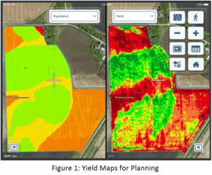
Technologies are now filtering down such that they’re available for farmers to use on subscription or ownership bases. Drones enable the farmer to control image capture, and own the frequency with which he conducts his field investigation. Multispectral imagery, “…can measure generic characteristics such as if a plant is healthy or not…” by capturing bands of light outside of the visible range.[i] This technology, also u sed by NASA scientists to detect the composition of meteors and planets, can be geographically overlaid on a map to show a farmer where in his field crop issues are occurring. Farmers are also collecting and controlling more data than ever before, employing Precision Planting equipment that can react to changing soil conditions real-time to modify seed dispersion and depth. Harvesters collect geo tagged yield data which is saved and analyzed later in the feedback loop to help inform future planting efforts. This information, combined with precise mechanical tools, enable the farmer to place a seed at the perfect distance from its neighbors.[ii] This dispersion is critical in that it facilitates growth without competition against the other plants, resulting in higher yields and ultimately more profit for the farmer. Finally, GPS enabled systems now essentially drive the tractors for the individual farmer, ensuring that proper speed and laser-straight headings are maintained.
With so many sensor platforms deployed to agriculture businesses, numerous big data startups have entered the community. Products such as Climate Corp’s FieldView platform (now a Monsanto company) collect vast quantities of data such as satellite imagery and enhanced NOAA weather streams.[iii] These data form a processing platform into which farmers can upload their own local information for the purpose of pulling out agronomic forecasts. These and other products can then be fed back to farmers on the ground who are consuming them real-time on mobile devices as they traverse fields. The overall goal for many companies is a central dashboard from which all relevant data can be visualized. Farmers will be able to link their in-field deployable sensors, their regional planting characteristics, and their various ERP systems to manage everything from the timing of nitrogen application to dialing in the exact seed coating a particular field requires.[iv]
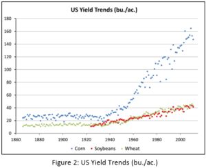
The application of these technologies has resulted in numerous benefits for the agriculture community. With the ability to geo-locate exactly where and what type of pest infestations are occurring, farmers are applying more targeted pesticides in fewer locations, resulting in fewer broad based pesticides leec hing into adjacencies and the water table. Deployable field sensors monitor soil hydrology levels and provide an accurate and real-time understanding of the growing conditions, to which farmers can respond with targeted water and fertilizer application.[v] As a result, crop yields – measured in bushels per acre – have been able to sustain their strongly upward trajectory (see figure 2)[vi]. Furthermore, targeted chemical application lowers the overall materials spend for farmers in addition to reducing equipment damage and fuel consumption through heavy use.
As with many technological trends, agricultural improvements are governed by the Hype Cycle. Many, such as drones, are seeing investment wane as market ebullience falls and waits for long-term business plans to take root (pun intended).[vii] Nonetheless, agriculture continues to benefit tremendously from technological improvement, with digital enhancements clearly being the next step to an efficient and highly productive farmer.
675 Words.
[i] AgFunder News, “IntelinAir CEO Al Eisaian on the Future of Aerial Imagery in Agriculture”, https://agfundernews.com/intelinair-ceo-al-eisaian-talks-the-future-of-aerial-imagery-in-agriculture.html, accessed November 2016.
[ii] Precision Planting, “YieldSense”, http://www.precisionplanting.com/#products/yieldsense/, accessed November 2016.
[iii] AgFunder News, “What do Monsanto’s Plans to Open Up its Digital Platform Mean for the Agriculture Industry?”, https://agfundernews.com/what-do-monsanto-plans-to-open-up-its-digital-platform-mean-for-the-agriculture-industry.html, accessed November 2016.
[iv] Climate Insights, “Planning and Monitoring Tools are Essential to Supporting Healthy Corn Development Through Harvest”, http://www.climateinsights.com/tools-for-healthy-corn-harvest/, accessed November 2016.
[v] Climate Insights, “Sensors and Connecting the Field”, http://www.climateinsights.com/?randomId=Z0Rx29W26BT5m&_ga=1.192630954.123526976.1479387992, accessed 2016.
[vi] USDA, “Estimating US Crop Yields”, https://www.nass.usda.gov/Education_and_Outreach/Reports,_Presentations_and_Conferences/Presentations/Johnson_Winrock_12.pdf, accessed November 2016.
[vii] AgFunder News, “AgTech Investing Report,” https://agfundernews.com/agriculture-technology-trends-agtech-captures-attention-h1.html, accessed November 2016.


Excited to see this post because I’m a big proponent of applying tech to agriculture (an industry that has been super slow to adopt advances historically). What is neat to see is how well Drones and Agriculture practices go along together. Although agriculture has really benefited from using spatial imagery provided by drones, what is interesting to see is how much the agricultural benefits have helped support the rationale for using drones and provided a proof of concept for drones.
The opportunity I see here is to create a platform that “talks” to all the different hardware / database systems. For instance, how can the data the drones collect and the data the field sensors collect be combined to give a farmer a holistic view of a crop’s yield. It seems like right now these are distinct systems and it’s up to the farmer to collect the data from all the sources and make a decision based off of multiple data points.
Additionally, it would likely be helpful for farmers to form collectives or something similar to a credit bureau to combine data and see farming results across different farms. The farming industry is composed of siloed farms and by giving farmers access to data across farms, we may see big results in yields. So much is yet to come here!
Agree with LS, that this is a very exciting post, dfeldpausch! In particular, I’m intrigued by the implication that a digitally-supported detailed understanding of specific crop issues can lead to more targeted and therefore lower use of pesticides and fertilizers. On top of that, I wonder whether the same technology could be applied to organic farming, where yields have been historically lower and there are fewer chemical levers to pull. The ability to use area-specific yield data to optimize future plantings is promising, and could help to increase yields and lower the cost of organic produce to the market.
Nice post,
I agree with your point that digital solutions can help farmers have greater yields at a lower cost. Moving forward I am concerned about the economical viability of these solutions in both:
– countries that are developing
– plants that do not have high economical yields per unit of land
In these cases, it seems unlikely that anybody would invest in current digital solutions. How do you envision the market of digital agricultural solutions moving forward? Will it become a commodity or something only available in a few developed countries?
Thanks for the post, interesting reading about the field! I am a huge proponent of the technology and think it is very cool to learn more about. I think a part of the business model that may be interesting to consider is what type of growth these companies may expect as they move past initial early adopters. With the next group of farmers they are likely looking to convert to their platforms it will surely be much harder to convince them to make a large up-front time and capital investment in a new technology that they know little about. As you indicate as they get more data the more invaluable their platforms will become and getting the next type of farmer on-board could be even more important as big data analytics evolve.
Nice Post D. There is a lot of exciting work going on in this space. I’ve seen a few companies that are now employing drones to do flyovers for both visualization/spraying. Using the resulting visuals they are able to better plan what to plant and where. I’ve also got a friend working on app to improve water utilization on farms. Essentially sensors in the ground communicate with a server that uploads the information to a database and present it to the farmer via a web/mobile app interface. The service helps create an optimized irrigation schedule. (http://www.acuityagriculture.com/) As cool as these ideas are, it seems that adoption is low and they solutions themselves aren’t particularly cheap. I’m wondering what you think are the main barriers prevent mass adoption? Customer behavior or price?