Map Kibera: Empowering Africa’s Biggest Slum with Collective Wisdom

Kibera is the biggest slum in Africa, largely ignored by the government and the public due to its "invisibility". How crowd-sourcing approach changed the lives of people in Kibera, and what were the impacts?
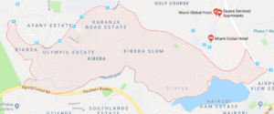
Several miles from the city center of Nairobi, the capital city of Kenya, Kibera slum houses about 250,000 people, said to be the biggest slum in Africa[1]. The basic infrastructure is lacking in the area, with 20% of which having the access to electricity, and unemployment rate is nearly 50%[2]. Despite the size and level of poverty in the area, Kibera has been largely ignored by those outside its community[3]. The slum was indeed invisible – even in Google map today, the slum is shown almost as blank except for major roads (See Exhibit 1 for Kibera Slum in Google Map). In November 2009, Mikel Maron and Erica Hagen began Map Kibera project to address “the glaring omission of roughly a quarter million of Nairobi’s inhabitants from mass communications and from city representation and policy decisions[4]” (See the video below for the project overview).
Exhibit 1: Kibera Slum in Google Map
Harnessing collective wisdom[5]
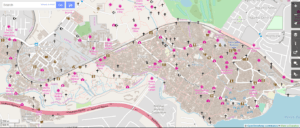
Instead of sending researchers to Kibera to develop the map, Maron and Hagen took a different approach: harness the collective wisdom the community already has[6]. They gathered young people in the slum (“mappers”), trained them how to use GPS devices, and sent them throughout the slum to collect the data. They used OpenStreetMap, a crowd-sourced map editable by anyone[7]. The mappers talked to residents in the slum to gather the community-owned information, and within three weeks, they developed the densest map ever made in Kibera[8] (See Exhibit 2 for OpenStreetMap by Map Kibera). Even though they were not paid by the project, they were motivated by gaining skills they would not learn otherwise, and by contributing to the community they grew up[9]. Furthermore, they were now regarded as holders of important information within the community[10].
Exhibit 2: OpenStreetMap by Map Kibera
Map Kibera Project did not stop here. The team began “issue-based mapping”, focusing on four areas: health, security, education, and water/sanitation[11]. For example, the team organized meetings with the women and girls in the slum, identified areas of rape incidents, and marked them as “black spots”[12]. They used such data for advocacy to the local authority, and six months later a new police post was erected on a former “black spot”[13]. All the data was collected by residents in the community, and recorded in OpenStreetMap.
The team also expanded its scope beyond mapping. They built a website called Voice of Kibera, to provide a strong, comprehensive picture of Kibera’s reality[14]. They again gathered young residents in the slum, trained them how to use WordPress for them to be able to publish posts[15]. Then they created an SMS shortcode with which anyone in the slum can report incidents and issues in Kibera via SMS[16]. In order to maintain the quality of information, the editorial board was set up to approve the incoming material[17]. Furthermore, the team set up Kibera News Network (KNN), a video journalism media using the similar approach. KNN covered not only negative incidents in the slum, but also the positive side of the community, such as Talent Show in Kibera[18]. Between April and September 2010, KNN covered 101 stories in Kibera.
Empowering the community
Even after Maron and Hagen left Kibera, Map Kibera is still actively managed by the local community. Maron and Hagen made it possible by creating a community-driven platform instead of top-down approach to collect the information. By making their own community visible to the public, the residents in the community strengthened their identity. Map Kibera also enabled the community to conduct effective lobbying and advocacy to the local authority, by providing detailed data and insights in the slum. Last not but the least, Map Kibera empowered young residents in the slum with hard skills (e.g., GPS, WordPress) and soft skills (e.g., interviews, public speaking), who are key driving force of improving the life standards in the community. Map Kibera set up a great use case on how technology and crowd-based approach can be used in the area of international development.
Photo credit
Cover picture: https://www.newscientist.com/article/dn23808-citizen-cartographers-fill-the-gaps-in-maps/
Exhibit 1: https://www.google.com/maps
Exhibit 2: http://www.openstreetmap.org/#map=15/-1.3128/36.7883
Endnote
[1] Kibera.org.uk, “Kibera Facts & Information”, accessed March 24, 2018, https://www.kibera.org.uk/facts-info/
[2] Ibid.
[3] Tavaana, “EMPOWERING NAIROBI’S SLUMS: THE MAP KIBERA PROJECT”, accessed March 24, 2018, https://tavaana.org/en/content/empowering-nairobis-slums-map-kibera-project#_edn3
[4] Hagen, Erica. (2011). Mapping Change Community Information Empowerment in Kibera. Innovations: Technology, Governance, Globalization, 6(1), p.70.
[5] Ibid., p.76.
[6] Ibid.
[7] Ibid., p.73.
[8] Ibid., p.74.
[9] Ibid.
[10] Ibid., p.75.
[11] Ibid., p.86.
[12] Supra note 3
[13] Ibid.
[14] Hagen (2011), p.78.
[15] Ibid. p.79.
[16] Ibid.
[17] Ibid.
[18] Ibid.p.84.


Thanks for the post Taka. This is a really interesting approach to crowdsourcing data. Beyond affecting policy decisions such as the establishment of the police post, I think such endeavours could go a long way towards driving collective action from the community. By providing community members a common platform to engage on the issues facing the community, I would imagine that it is also easier for residents of Kibera to begin driving other activities. I’d be interested to know to what extent this crowdsourcing has not just been a once of mapping event or something associated with publishing news, but a way of life for the residents to collaborate around interesting initiatives.